If you’ve driven Skyline Boulevard (Highway 35) south of Highway 92 anytime in the last couple of years, you’ve probably seen construction fencing and wondered what was going in. As of Monday, August 24, 2026, the answer opened to the public: the Skyline Watershed Ridge Trail, a new 6-mile segment of the Bay Area Ridge Trail cut through San Mateo County’s Peninsula Watershed.
I live for this kind of local infrastructure news — a genuinely new, genuinely free thing to do that’s surprisingly accessible from many parts of the Peninsula, opening with almost no fanfare. But there’s a catch that a lot of “new trail opens!” coverage is going to bury: you can’t just show up and walk on. It requires a permit. Here’s everything you need to know before you drive out there.
What actually opened
The Skyline Watershed Ridge Trail is a 6-mile, out-and-back segment built and managed by the San Francisco Public Utilities Commission (SFPUC) — yes, the same agency that runs San Francisco’s water system. It sits inside the 23,000-acre Peninsula Watershed, which has been protected as a municipal drinking-water source for roughly 150 years. San Francisco acquired the Spring Valley Water Company’s watershed assets — including this land — in 1930, and it’s been managed by SFPUC as part of the Hetch Hetchy Regional Water System ever since.
During construction it was known as the Southern Skyline Ridge Trail Extension — if you’ve seen that name on a planning document or old news clip, it’s the same project. The trail runs from the parking area near the Highway 35/92 interchange south to the Phleger Estate boundary, with a future connection planned to Purisima Creek Redwoods Preserve. It’s a genuine piece of a much bigger regional project: the Bay Area Ridge Trail, a planned continuous 550-mile trail circling the entire Bay Area along the ridgelines. This new stretch brings that project to 413 completed miles.
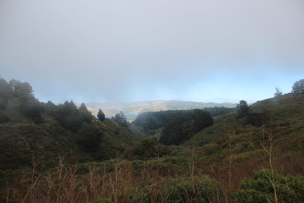
What you’ll see: sweeping views of the Peninsula Watershed’s reservoirs (including Crystal Springs Reservoir), open shrubland, and forest, plus ten interpretive panels along the route explaining the watershed’s role in the region’s drinking water system and its status as a State Fish and Game Refuge and part of the UNESCO Golden Gate Biosphere Reserve.
The permit — the part most people will miss
This is the detail that separates this trail from basically every other regional park trail in the Bay Area: entry requires a free permit, and you cannot just walk up to the trailhead without one.
- Cost: Free
- Where: Apply online through SFPUC’s trail permit portal (linked from the official trail page)
- Processing time: Available for immediate use — you can apply and be cleared to hike the same day
- Validity: Good for the full calendar year once issued
- Guests: SFPUC’s own pages aren’t perfectly consistent here, so it’s worth stating both. The general trail page describes the permit as covering “up to 6 people in a group.” SFPUC’s dedicated Permit FAQ (dated August 18, 2026) is more specific: each permit holder can bring up to six guests, guests don’t need to be individually registered under the permit holder’s account, and who you bring can change from visit to visit. Practically, that means: one person enrolls, and up to six others can join them on any given trip without their own separate permit.
- Proof of permit: You don’t need a physical, printed copy. After you enroll, SFPUC sends a confirmation email that serves as your proof — you can also screenshot your enrollment page. Watershed staff patrolling the trail may ask to see it, and either the email or the screenshot is sufficient.
Practical tip: apply before you leave home and save a screenshot of your confirmation to your phone. SFPUC says cell service is available along most of the trail (and if you lose signal, walking a few feet usually gets it back), but don’t count on solid reception right at the trailhead itself — better to have your proof saved locally than to assume you can pull it up live.
Who can use it, and who can’t
The trail is genuinely multi-use, which is unusual for SFPUC watershed land:
- ✅ Hikers and runners
- ✅ Bikers (regular, non-motorized bikes — mountain bikes are recommended given the surface and grade)
- ✅ Equestrians
- ❌ No dogs — this one surprises people, but it’s standard for SFPUC watershed land, protecting water quality and the wildlife refuge designation. Service animals are the exception.
- ❌ No e-bikes, scooters, or any motorized vehicles
What the trail actually feels like
This is not a flat stroll. A few numbers worth knowing before you commit:
- Length: 6 miles one-way (12 miles round-trip if you’re doing the full out-and-back)
- Surface: 6-foot-wide crushed rock, built for multi-use traffic
- Elevation: Net change of roughly 1,200 feet between the two ends, with total elevation change (up and down combined) closer to 1,800 feet
- Grade: Slopes ranging from a gentle 6% up to a genuinely steep 23.5% in sections — that’s a real climb, not a warm-up hike
Translation: if you’re going for the full 12-mile round trip, treat it like the moderate-to-strenuous hike it is, not an casual afternoon walk.
Getting there and what to bring
Parking: A dedicated lot on Highway 35 (Skyline Boulevard), just south of the Highway 92 intersection near Skylawn Memorial Park. It’s small — 22 standard spaces, 5 trailer spaces, and 2 ADA spaces — and it’s free, first-come-first-served. This is a brand-new trail with no track record yet on how fast that lot fills, so in the first few weeks especially, get there early.
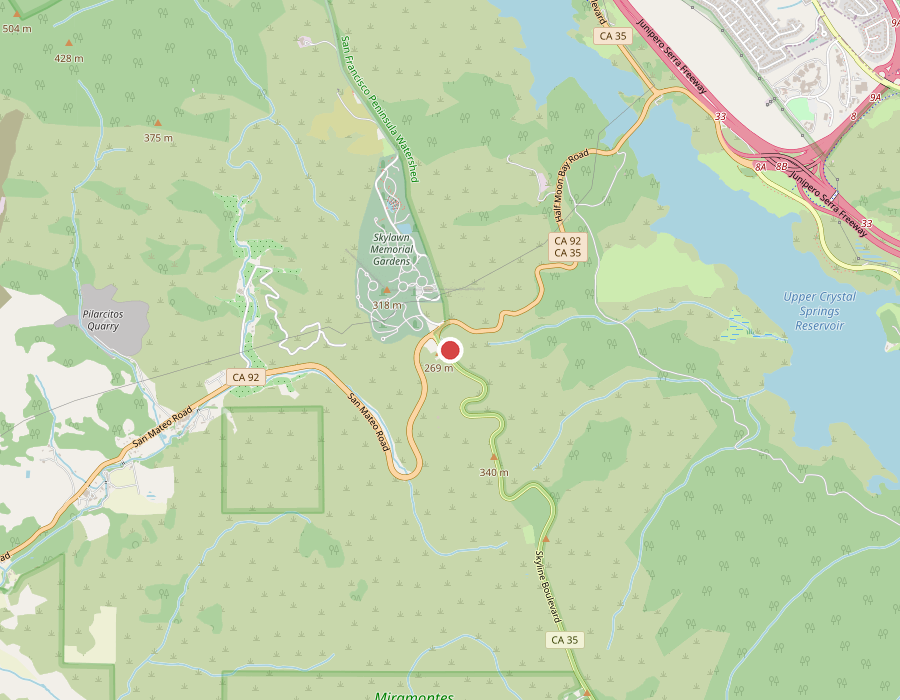
The trailhead parking lot sits right at the Highway 92/35 junction, next to Skylawn Memorial Gardens and Upper Crystal Springs Reservoir. Map data © OpenStreetMap contributors.
- From the north: From the Highway 92/35 intersection, go south on Highway 35 about 0.1 miles — the lot is on your left.
- From the south: From the Highway 84/35 intersection, go north on Highway 35 about 12.3 miles — the lot is on your right.
- Coordinates for your maps app: 37°29’39.9″N 122°22’03.1″W
Hours: Gates open 6 am, close 6 pm daily.
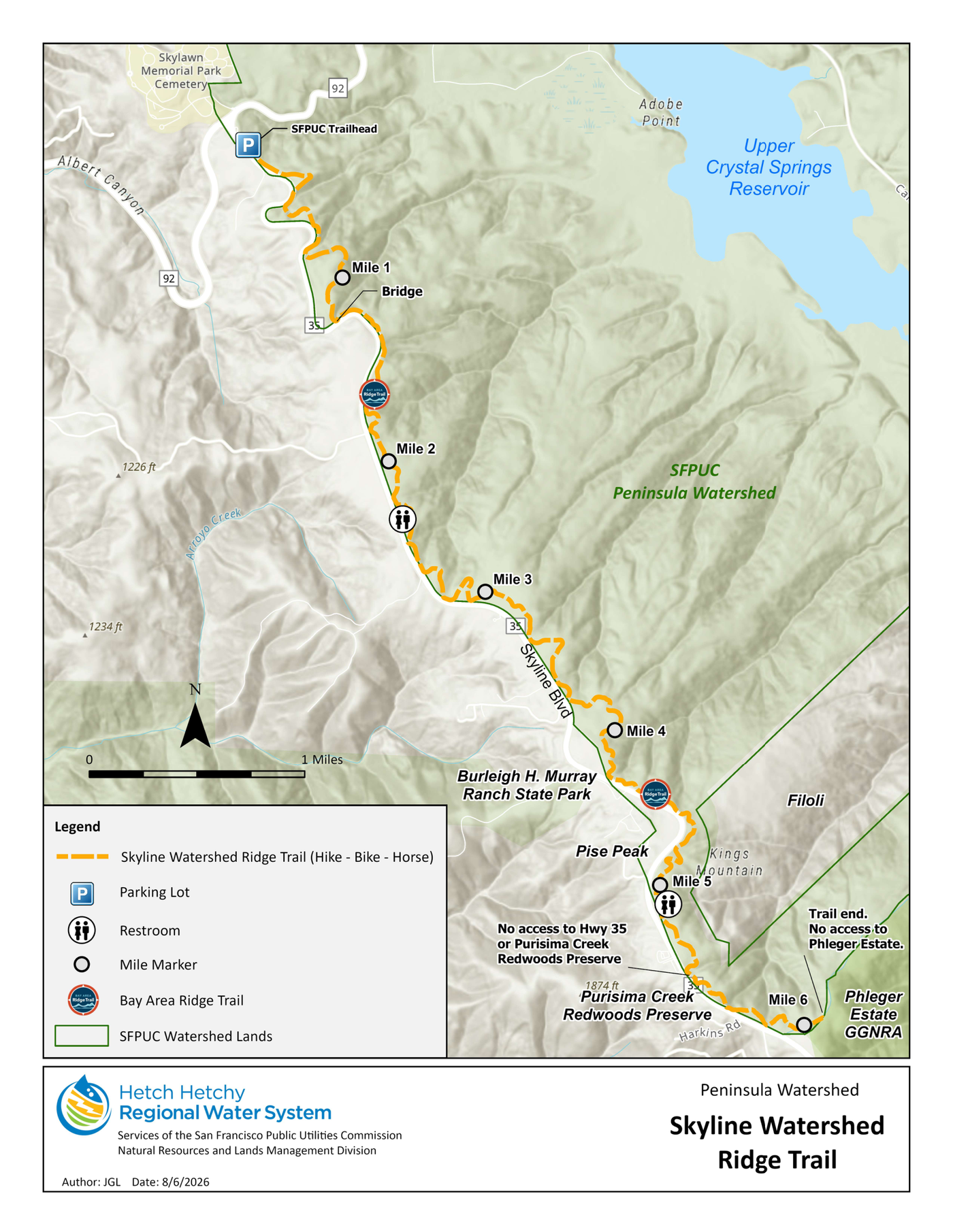
The actual trail alignment, straight from SFPUC’s official trail map (published August 6, 2026) — it winds with the ridgeline rather than running in a straight line. Shows mile markers 1–6, both restroom locations, the Highway 35 corridor, and the Purisima Creek Redwoods / Phleger Estate boundary at the southern end. Map: San Francisco Public Utilities Commission (SFPUC), Hetch Hetchy Regional Water System.
Maps:
- Google Maps — direct pin to the trailhead parking lot (this is SFPUC’s own official link, coordinates 37°29’39.9″N 122°22’03.1″W — punch it straight into your phone)
- Official SFPUC trail map (PDF) — the authoritative route reference, same map embedded above
- Bay Area Ridge Trail interactive map — Ridge Trail Council’s map tool showing how this segment fits into the larger 550-mile network
What the map does (and doesn’t) connect to. This is a straightforward out-and-back, not a loop or a through-route:
- It’s about 6 miles one way, roughly 12 miles round-trip
- There’s no exit at the southern end — you turn around and hike back the way you came
- No intermediate access to Highway 35 anywhere along the route
- No current access into Purisima Creek Redwoods Preserve from this trail (a connection is planned, but it isn’t built yet)
- No current access into the Phleger Estate from the trail’s southern terminus — SFPUC’s own map marks it plainly: “Trail end. No access to Phleger Estate.”
Pack for zero services on trail. There’s no potable water, no trash cans, and no restrooms at the trailhead itself — vault toilets are located near mile markers 2 and 5, but that’s it. Bring all your own water, pack out everything you bring in, and plan your bathroom stops around those two points if you’re going the distance.
Why this matters beyond “new trail, cool”
Two things stood out to me digging into this. First, the permit model here is a genuinely different approach than how Bay Area open space usually gets managed — SFPUC is opening working watershed land (land whose primary job is protecting the region’s drinking water supply) to recreational use, using managed access to reduce impact rather than just throwing the gate open: annual registration, no dogs, no motorized traffic, a stay-on-trail requirement, and watershed staff who actually patrol and enforce it. Worth noting: SFPUC’s own permit FAQ says permits are free and not limited in number — this isn’t a fixed daily-visitor-cap system like a timed-entry park reservation, it’s closer to a registration-and-rules gate. If it works well here, it’s a reasonable template for other utility-owned land around the Bay that’s historically been off-limits.
Second — and this is the more practical point — if you’ve been holding out hope that the Bay Area Ridge Trail will someday actually be a continuous 550-mile loop around the whole region, this is a real, measurable step toward that (413 of 550 planned miles now complete), not just an announcement. The planned connection south to Purisima Creek Redwoods Preserve would close another real gap in the network — though as of this writing that link doesn’t exist yet, so don’t plan a trip assuming you can hike through.
Trail rules and hazards, at a glance
Beyond the permit itself, the rules are straightforward but worth knowing before you’re standing at the trailhead gate:
Prohibited: dogs/pets (service animals excepted), e-bikes and other motorized vehicles, smoking, alcohol, fires and fireworks, camping, weapons, and drones.
Required: stay on the designated trail, pack out everything you bring in, don’t disturb or collect plants or wildlife (including wildflowers), use the boot/tire/hoof cleaning stations where posted, and cyclists yield to hikers and equestrians.
Stay alert: SFPUC’s own permit flags mountain lions, ticks, and poison oak as commonly found in the watershed — nothing unusual for Bay Area open space, but worth the standard precautions (check for ticks after, learn to spot poison oak, give wildlife space).
Quick-reference checklist before you go
- Apply for your free permit online — don’t wait until you’re at the trailhead
- Save a screenshot of your permit confirmation email before you leave home
- Check the weather — this is an exposed ridgeline trail with real elevation change
- Bring all your own water; there’s none on trail
- Leave the dog at home
- E-bike riders: bring your regular bike instead, or pick a different trail
- Arrive early — trailhead parking is limited (22 standard + 5 trailer + 2 ADA spaces)
- Plan bathroom stops around mile 2 and mile 5 (vault toilets only)
- Decide up front: one-way out-and-back to a turnaround point, or the full 12-mile round trip — this is not a trail to commit to blind
Official source and permit link: SFPUC — Skyline Watershed Ridge Trail
Photo: Upper Crystal Springs Reservoir Vista Point, near the trail’s northern access point off Highway 35 — the exact landmark SFPUC uses in its own driving directions to the new trailhead.