Not every coastal ride needs to become a Big Sur expedition. Santa Cruz to Monterey works as a ride with two waterfront destinations: stop, walk around, eat something, and leave enough time to enjoy the bay instead of treating it as a gap between corners.
My recommendation is to anchor the day around the Santa Cruz waterfront and Monterey’s Old Fisherman’s Wharf. Use Highway 1 for the connection, add town stops only when you want them, and remember that this is a working highway—not an uninterrupted ocean-view promenade.
The route: waterfront to waterfront
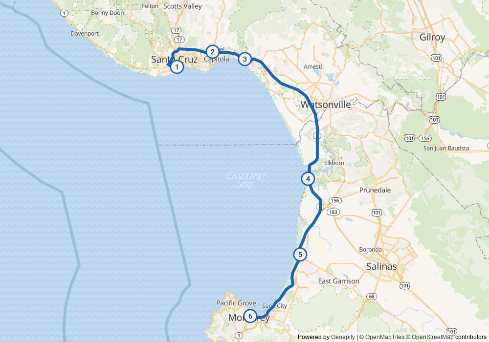
Start near Santa Cruz Wharf, join southbound Highway 1, and follow the corridor past the Capitola and Aptos area toward Moss Landing, Marina and Seaside before leaving the highway for Monterey’s waterfront. Capitola village and other waterfront detours require leaving Highway 1; the through route does not visit every town center.
Plan this as a relaxed half-day outing if you want time for food and walking, not as a guaranteed travel time. Your starting point, detours, traffic and return journey determine how much day you need. The map below is a calculated planning route through public waypoints, not a GPS recording of my ride or turn-by-turn directions.
First stop: Santa Cruz Wharf
The City of Santa Cruz’s official Wharf page lists dining, shopping and visitor information. Make it a stop rather than a quick ride-by: park where permitted, take a walk, and decide whether this is your first meal stop or simply a chance to look around.
Check the city’s current access notices before heading there. On November 16, 2026, the city page still carried a high-surf closure notice covering November 13–15. That notice’s end time is not independent confirmation of reopening. Coastal facilities can close when surf or weather makes access unsafe.
Follow current signs and posted parking rules. Do not assume a motorcycle gets free parking, can bypass a closure, or can ride wherever pedestrians are allowed.
The middle: choose stops, not obligations
You can keep the ride simple on Highway 1 or leave the highway for an optional break around Capitola, Aptos or Moss Landing. Pick a stop because you want to spend time there—not because a route guide has turned lunch into a checklist.
Build in flexibility for traffic and changing visibility. Freeway sections, merging vehicles and busy intersections require attention even when the route is less focused on tight mountain corners. “Coastal” does not mean automatically beginner-safe, empty or slow.
Finish: Old Fisherman’s Wharf, Monterey
Old Fisherman’s Wharf’s visitor information provides waterfront parking directions and links to dining and shops. Aim for a legal parking area near the waterfront, then explore on foot. Do not navigate straight onto the wharf assuming it is a motorcycle destination road.
This is the other place to leave time for food and looking around. Check individual merchants’ hours rather than relying on a general promise that every restaurant will be open. I am recommending the waterfront stop, not claiming a firsthand review of a particular restaurant or dish.
Before leaving home
- Road conditions: Check Caltrans QuickMap for incidents and lane closures, plus Caltrans Highway 1 conditions. A clear route map does not establish today’s access.
- Weather: Check the local forecast and coastal alerts. Leave room to change plans for fog, rain, strong wind or surf-related closures.
- Clothing: Bring layers for time off the bike as well as the ride. A warm departure does not promise a warm waterfront stop.
- The return: Decide whether you are returning the same way, staying in Monterey or continuing elsewhere. The route here ends at Monterey; a return is additional riding.
- The bike: Check tires, fuel and the usual pre-ride items before leaving. Do not turn a relaxed outing into a rushed ride home after dark.
From the field
I’ve ridden from Santa Cruz to Monterey, and I recommend stopping at the piers in both towns. There’s plenty to see and good food to enjoy along the way.
Let the stops be the point
For this ride, the waterfront time is part of the ride—not time stolen from it. Keep the itinerary loose enough to walk around, choose your meal without rushing, and change the plan when the weather or traffic does not cooperate.
Planning sources: City of Santa Cruz Wharf information; Old Fisherman’s Wharf visitor information; Caltrans QuickMap. Access information checked November 16, 2026; recheck before riding.